
Cuyamaca Trail Trekker Challenge
Cuyamaca Rancho Challenge Hikes are about exploring the park, enjoying the trails, and most importantly, getting rewards for your efforts! The Challenge Hikes feature a mixture of popular trails and trails less traveled.
RULES
Choose Your Own Adventure:
- Pick either the Three Peaks, Two Hikes or the Five Hikes challenge.
- Complete the challenge by taking a selfie at teh points described for your challenge choice.
- After you have finished all five hikes, go to the visitor center on either a Saturday or Sunday and show the person at the visitor center.
- Collect your pin or patch. You are now a Cuyamaca Trail Trekker!
Accessible Challenge
- The Accessible Challenge is a distance challenge. Use whatever means of transportation work best for you.
- Go a minimum of two miles total. You can choose to go farther.
- Take selfies of yourself in the different places you go in the park.
- After you have gone whatever distance you have decided to go for your challenge, go to the visitor center and show your selfies to the person at the visitor center.
- Collect your pin or patch. You are now a Cuyamaca Trail Trekker!
You have one calendar year to complete the challenge.
Rewards:
|
Name |
Mileage |
Description |
Photo Location |
|
Cold Spring Trail |
5.2 |
This hike starts from West Mesa Parking and heads north along the Coldstream Trail. The trail starts out uphill then heads downhill as you continue to the Stonewall Creek Fire Road. At the junction of Cold Spring and Stonewall Creek Fire Road turn right, head downhill to the Upper Green Valley Fire where you will make another right turn until you reach the Hill Trail. Here you will turn right and continue until you reach Coldstream Trail, where a right turn brings you back to where you started. |
Cold spring trial and Stonewall Creek Fire Road meet. |
|
Stonewall Peak |
2.2 |
It is considered a moderate trail with steepest parts and bottom and at the top. The trail provides views to all the directions on the top including the lake. It's heavily switch backs to get to the peak. There is beautiful scenery of wildflowers in the spring. |
Place 1- On top of the peak, Place 2-At the end of trail before the peak |
|
Azalia Glen Loop Trail |
3.7 |
This trail begins from Paso Picacho and continues to the Azalea Spring Fire Road and then turns onto the Azalea Glen Fire Road back to Paso Picacho. Along the way you can see bedrock mortars created by the Kumeyaay and follow the Azalea Creek. The Azalea Creek area is reminiscent of the park before the 2003 Cedar Fire. This is a moderate hike with areas of rocky tread and damp sections. |
By the Azalea Springs sign or the spring house. |
|
The Fages Monument Loop Trail |
5.7 |
Park at the Fages Monument off Sunrise Highway and cross the road to the La Cima Trail. The La Cima Trail turns into the Upper Green Valley Trail. Continue to the Soapstone Grade Fire Road and make a right turn. When you get to the junction of the Soapstone Grade Fire Road and the California Riding and Hiking Trail make another right turn. This will return to you Sunrise Highway. |
At the junction of the Soapstone Grade Fire Road and the California Riding and Hiking Trail. |
|
East Side/West Side Loop |
6.2 |
Park at the Visitor Center and follow the Upper Green Valley Fire Road through the Outdoor School. Turn right onto the Harvey Moore Trail, crossing the Sweetwater River and continuing to the East Side Trail. After crossing Harper Creek, follow the trail to Sweetwater Parking. Cross Highway 79 to the Japacha Fire Road/West Side Trail. Turn right on the West Side Trail, then take the connector back across Highway 79 and use the access road to return. This is a moderate, mostly flat hike. |
Spot 1- Where Eastside Trail and Harvey Moore meet. Sport 2- Dyre Springs where Eastside Trail meets. Spot 3- Where the Westside Trail and Japacha meet. |
Acceisbile Challenge Hike Suggestions
Accessible Challenge Hikes are suggested hikes for those that wish to explore the the park. There are no requirements to take photos and there are no rewards associated with these suggested hikes.
|
Name |
Mileage |
Description |
Map |
|
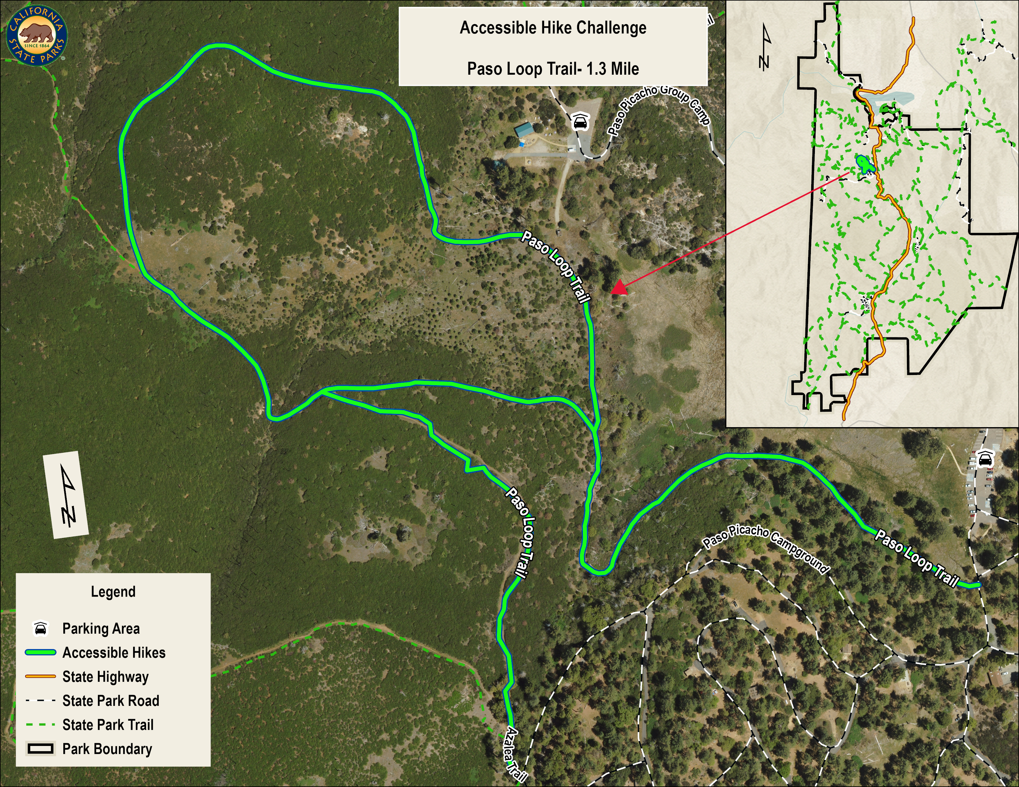
Paso Loop Trail |
1.3 |
This walk starts at in the forested area pf Paso Picacho and heads through a reforested area. Continue to the bench at the trail junction and turn right. Continue on the trail to the next junction. Head back to the parking area. |
MAP |
|
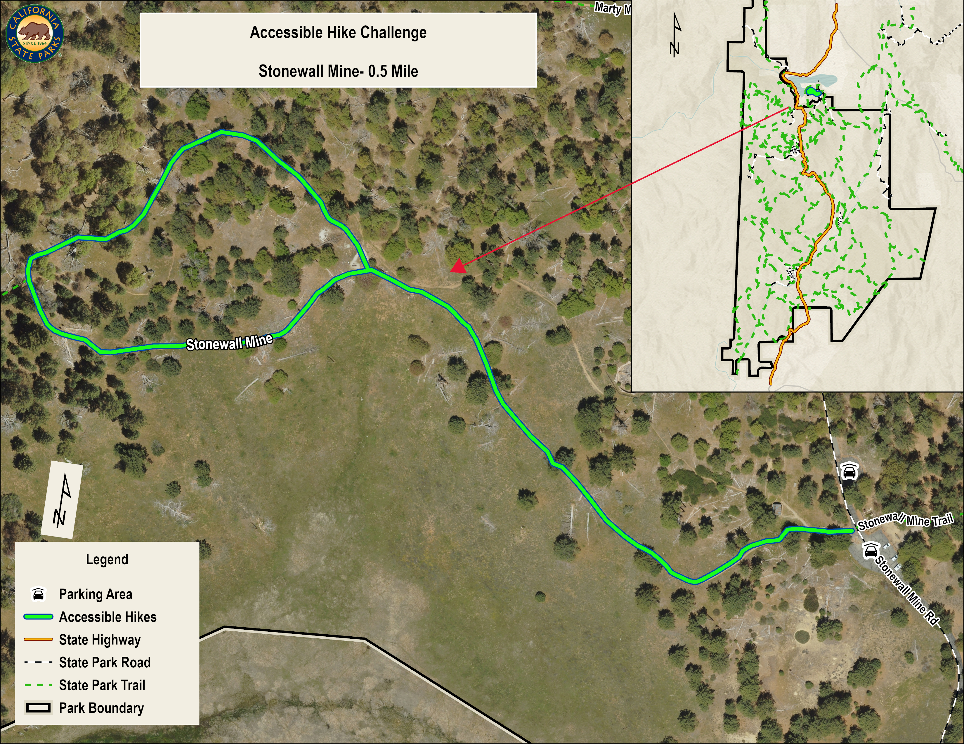
Stonewall Mine |
0.5 |
Start at Stonewall Parking. This trail goes along a hillside that has views of Cuyamaca and Stonewall peaks. The trail continues past a birding bench and continues in a loop back to the bench to reconnect with the trail that will take you back to the parking area. |
|
|
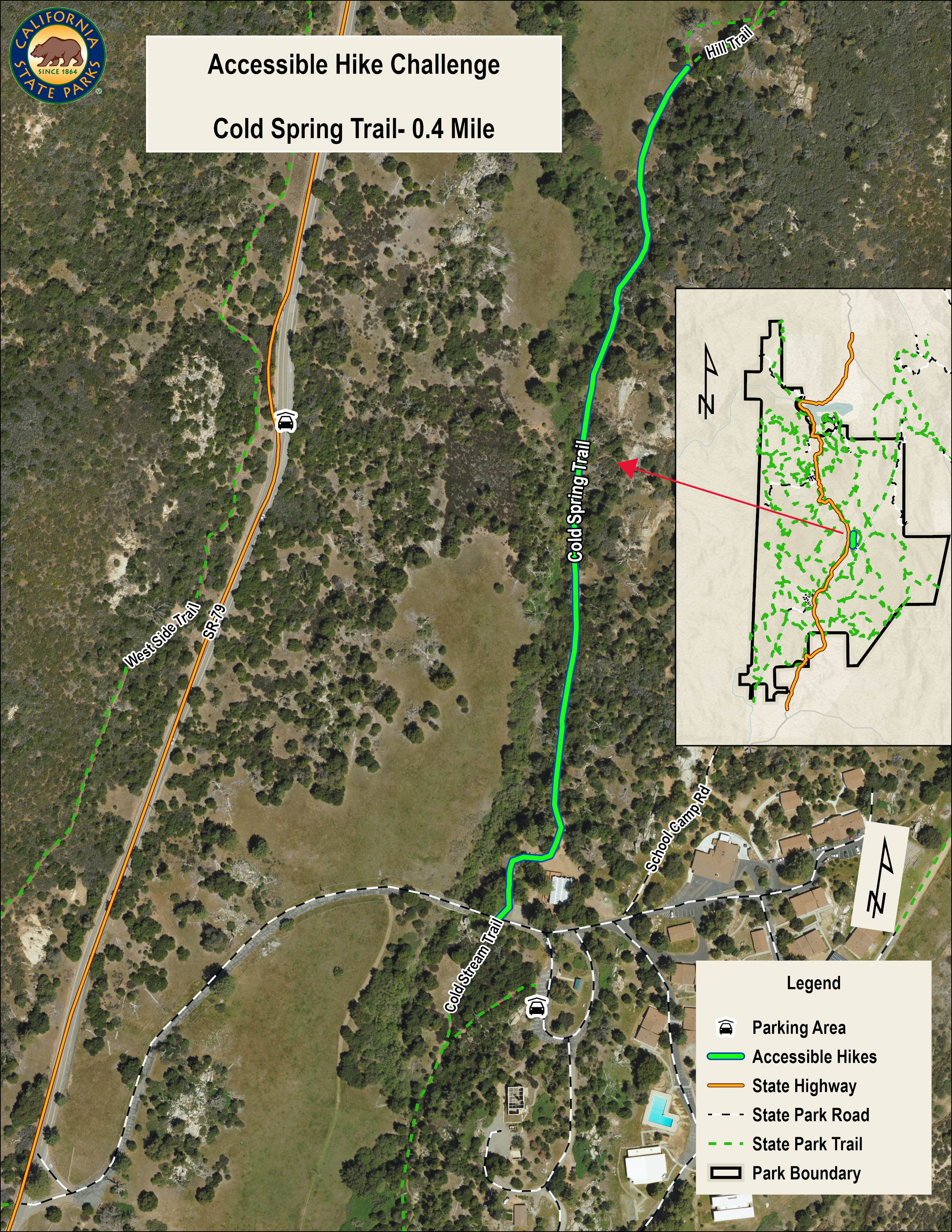
Interpretive Trail from the Visitor Center |
0.4 |
This walk starts on the Cold Stream Trail by the visitor center. The trail is flat until in passes an area with morteros where it becomes trenched. The interpretive trail ends at a meadow with a view of Stonewall Peak. |
|
|
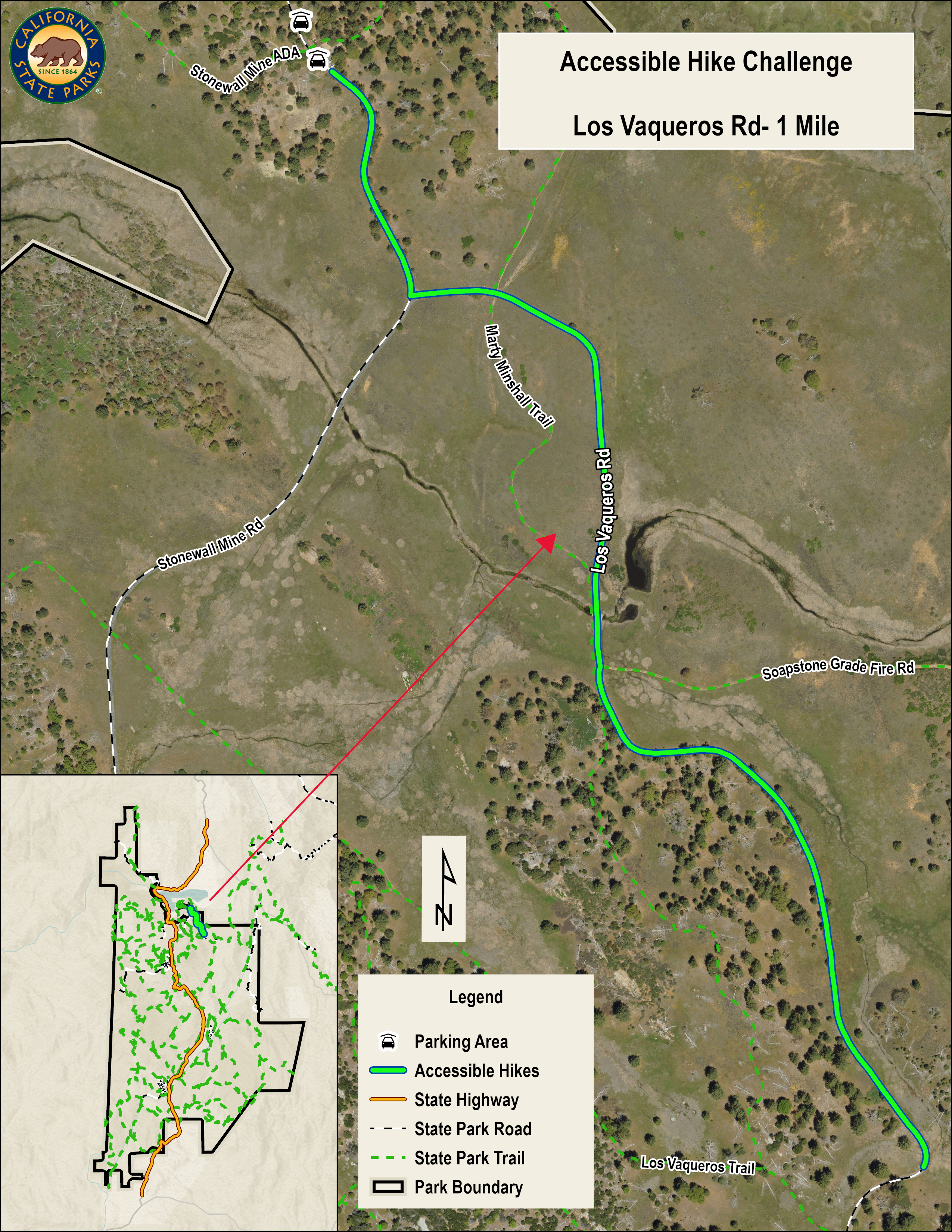
Los Vaqueros Rd |
1 |
This paved road is accessed from Stonewall Mine Parking. The walker will need to walk along the Mine Road a short way to the gate for the Los Vaqueros Road. Go around the gate to access the road. The area is a mix of meadows and forest. Please do not go all the way to Los Vaqueros Horse Camp if the camp is in use. A bonus for this walk is that your dog can come with you. |
|
|
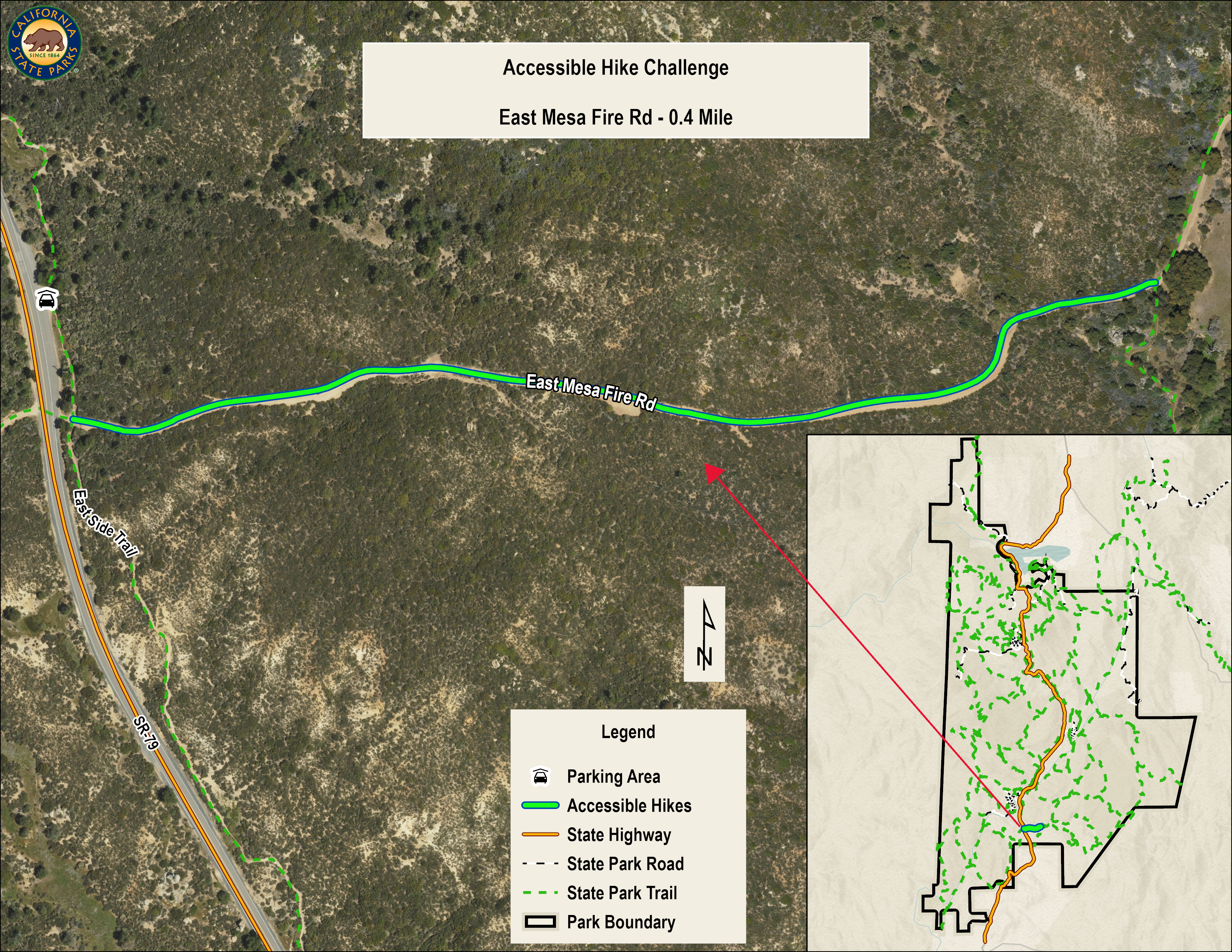
East Mesa Fire Rd |
0.4 |
East Mesa Parking provides the starting point for this walk. Go out of the parking area to the chain link gate and go around the gate to the fire road. The road is wide with a gravel base. The walk starts uphill for a short distance before it flattens out. The road starts to go uphill after the junction with the Upper Descanso Creek Trail. |